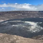
Kīlauea volcano is not erupting at this time, however low-level seismicity continues beneath the summit and Southwest Rift Zone, while rates of ground deformation remain low.
Right now, low levels of seismicity continue beneath Kīlauea’s summit. During the past week, the rate of earthquakes in this area were slightly elevated. Daily earthquake counts remain well below those detected during the January–February intrusion or prior to recent summit eruptions. At this time, earthquake depths beneath the summit are primarily 0.3–1.6 miles (0.5–2.5 kilometers) below the surface, and magnitudes are typically below M2.0.
Ground deformation continues at low rates across Kīlauea, with tiltmeters near Uēkahuna and Sand Hill—respectively northwest and southwest of the summit caldera—showing only modest changes over the past week.
Sulfur dioxide (SO2) gas emissions have remained at low, noneruptive levels since October 2023. An SO2 emission rate of approximately 60 tonnes per day was recorded on March 27.
Low levels of seismicity continue beneath Kīlauea’s Southwest Rift Zone. During the past week, daily earthquake counts remained well below those detected during the January–February intrusion. No unusual activity has been noted along the East Rift Zone.
Measurements from continuous gas monitoring stations downwind of Puʻuʻōʻō in the middle East Rift Zone—the site of 1983–2018 eruptive activity—remain below detection limits for SO2, indicating that SO2 emissions Puʻuʻōʻō are negligible.
The Hawaiian Volcano Observatory (HVO) continues to closely monitor Kīlauea Volcano.
Photo credit: USGS
