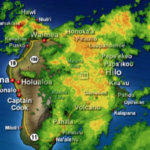

Tropical Storm Calvin Advisory Number 31
NWS Central Pacific Hurricane Center Honolulu HI EP032023
1100 PM HST Tue Jul 18 2023
…TROPICAL STORM CALVIN BEGINNING TO PASS SOUTH OF THE BIG ISLAND……IMPACTS IN HAWAII COUNTY ARE IMMINENT OR OCCURRING…
SUMMARY OF 1100 PM HST…0900 UTC…INFORMATION
———————————————–
LOCATION…17.7N 155.2W
ABOUT 140 MI…220 KM S OF HILO HAWAII
ABOUT 305 MI…490 KM SE OF HONOLULU HAWAII
MAXIMUM SUSTAINED WINDS…50 MPH…85 KM/H
PRESENT MOVEMENT…W OR 275 DEGREES AT 20 MPH…31 KM/H
MINIMUM CENTRAL PRESSURE…1003 MB…29.62 INCHES
WATCHES AND WARNINGS
——————–
CHANGES WITH THIS ADVISORY…
None.
SUMMARY OF WATCHES AND WARNINGS IN EFFECT…
A Tropical Storm Warning is in effect for…
* Hawaii County
A Tropical Storm Warning means that tropical storm conditions are expected somewhere within the warning area.
At 1100 PM HST (0900 UTC), the center of Tropical Storm Calvin was located near latitude 17.7 North, longitude 155.2 West. Calvin is moving toward the west near 20 mph (31 km/h) and this motion is expected to continue for the next few days.
Maximum sustained winds are near 50 mph (85 km/h) with higher gusts. Some weakening is forecast during the next 48 hours. Tropical-storm-force winds extend outward up to 140 miles (220 km) from the center.
The estimated minimum central pressure is 1003 mb (29.62 inches).
HAZARDS AFFECTING LAND
———————-
WIND: Tropical storm conditions are imminent or occurring within the warning area this evening. Preparations for tropical storm force wind impacts should already be completed for persons in Hawaii County. Seek shelter.
RAINFALL: Storm total rainfall amounts through Thursday are forecasted to be 4-8 inches, with maximum amounts of 10 inches possible, mainly along the windward slopes and southeast flank of the Big Island of Hawaii. Storm total rainfall amounts of 3-6 inches are expected on the windward areas of Maui, and 2-4 inches elsewhere in the state. This rainfall could lead to localized flash flooding and mudslides.
SURF: Swells generated by Calvin will spread across the main Hawaiian Islands tonight. This will lead to a rapid increase in surf along east facing shores, with high surf continuing into Wednesday. This elevated surf will likely cause life-threatening conditions along exposed shorelines.
NEXT ADVISORY
————-
Next intermediate advisory at 200 AM HST.
Next complete advisory at 500 AM HST.