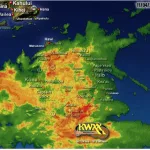
The National Weather Service in Honolulu has extended the Flash Flood Warning for the Island of Hawaii until 1:45am on Tuesday.
At 1033 PM HST, radar and automated rain gauges indicated heavy rain falling over mainly southeast and interior portions of the Big Island moving into leeward Big Island. Rain was falling at a rate of 1 to 2 inches per hour with additional heavy rain expected to move into southeast Big Island over the next couple of hours.
Emergency management continues to report multiple road closures across windward and southeast Big Island. Flash flooding is ongoing or expected to begin shortly.
HAZARD…
Flash flooding caused by heavy rain.
SOURCE…
Radar and automated gauges.
IMPACT…
Flooding in drainages, streams, rivers, roads, properties, and other low-lying areas. Public road closures possible in some areas. Landslides are possible in steep terrain. Some locations that will experience flash flooding include: Hilo, Kailua-Kona, Hawaiian Paradise Park, Captain Cook, Waikoloa Village, Kapaau, Honokaa, Pohakuloa Training Area, Pohakuloa Camp, Volcano, Wood Valley, Glenwood, Honaunau, Hawaii Volcanoes National Park, Honalo, Mountain View, Kainaliu, Kealakekua and Puuanahulu.
PRECAUTIONARY/PREPAREDNESS ACTIONS…
Stay away from streams, rivers, drainage ditches, and culverts, even if they are currently dry. Do not cross fast flowing or rising water in your vehicle, or on foot. Turn around, don`t drown. Be especially cautious at night when it is harder to recognize the dangers of flooding. This warning may need to be extended beyond 145 AM HST if flooding persists.