With the start of the new eruption of Halema’uma’u, which is confined to the crater inside Hawaii Volcanoes National Park, the mix of volcanic gasses has returned. The areas from Pahala around the south part of the island up through North Kona are the areas most affected. Because of wind patterns, Hilo, Puna, and the Hamakua Coast have remained visibly vog-free. As long as the winds are in a tradewind pattern, that should continue. Debbie Walsh, a Puna resident, said on Tuesday that Hawaiian Paradise Park had blue skies and white clouds.
West Hawaii residents have enjoyed crystal clear skies since the end of the 2018 eruption, which was officially determined to be September 4, 2018. The vog literally stopped and residents around the island–including the South and West areas–have enjoyed clear air, clouds, and beautiful sunsets since then.
Hawaiian Volcano Observatory’s Kilauea update today notes that “Large amounts of volcanic gas—primarily water vapor (H2O), carbon dioxide (CO2), and sulfur dioxide (SO2)—are continuously released during eruptions of Kīlauea Volcano. As SO2 is released from the summit during this new eruption, it will react in the atmosphere with oxygen, sunlight, moisture, and other gases and particles, and within hours to days, convert to fine particles. The particles scatter sunlight and cause the visible haze that has been observed downwind of Kīlauea, known as vog (volcanic smog), during previous summit eruptions. Vog creates the potential for airborne health hazards to residents and visitors, damages agricultural crops and other plants, and affects livestock operations. ”
The eruption is contained within Halema’uma’u crater, with no danger to people or structures, and HVO says the situation is unchanged since Tuesday. But the volcanic emissions which create vog go into the air and are blown to the south and west, and wrap around the West side of the Big Island. That is the general pattern for vog from Kilauea, unless the winds shift and become “Kona winds,” which blow in the opposite direction from the trade winds. That’s when East Hawaii gets vog.
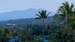
The photo below, courtesy Dan Sabo, is of Hualalai Mountain, taken Tuesday morning, Dec. 22, around 7:30 a.m. from Holua Resort on Kaleiopapa Street. Up until that morning, skies had virtually no vog and the view of Hualalai Mountain was sharp enough to see the trees. Tuesday morning, the vog began in earnest, and then blowing southwest, wrapped itself around the island from Halema’uma’u up the west side of the island.

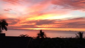
One of the effects of the vog is that it obscures the clouds, not only during the day but also those that create the spectacular sunsets one can see from West Hawaii. This photo was taken on Oct. 15, 2018, less than 6 weeks after the official end of the 2018 eruption, around 3 miles south of Kailua Village.

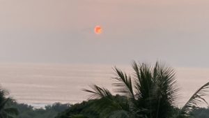
This photo was taken of “sunset” on Dec. 22, 2020 from the same location.

For the State Department of Health guidance on short-term sulphur dioxide (SO2) levels, click here
Vog information can be found at the Hawaii Interagency Vog Information Dashboard at https://vog.ivhhn.org
